Thursday, May 24, 2012

Street Scrambles (or, a few of my favorite things)

This map will be of dubious utility in Gig Harbor

This Saturday, May 26, is the perfect chance to try out a Street Scramble, since there is a free one in Gig Harbor (just across the Tacoma Narrows Bridge).  It's a beautiful spot, the weather is going to be great, you were going to get out of the city anyway, and did I mention it's free?

Street Scrambles are basically urban scavenger hunts:  you get a map with around 30 checkpoints circled, each of which has a number from 10-59.  Each checkpoint you visit is worth 10-50 points based on the number:  Numbers 10-19 are worth 10 point each, 20-29 are worth 20 each, etc.  The object is to get as many total points as you can within a time limit (at Gig Harbor, either 90 minutes or 3 hours) by visiting checkpoints.  You prove you visited a checkpoint by answering a simple multiple choice question.  For example:
Park sign
At what time does the park close?
a) 10pm  b) 11pm c) open 24 hours
You must travel under your own power, except kids can be pushed, carried, etc. by older folks (so, strollers are allowed).  There are numerous competition classes, based on how you get around and how old the people are on your team, so that families with strollers are not competing with adults on bikes.  The prizes are pretty minimal (top 5 in each class get a ribbon, winner in each class gets a pen, I believe).  But another good thing about going to Gig Harbor is they have a little festival set up at the starting line, so you can get balloons and other small prizes, there is usually a touch tank with tide pool creatures, and the last few years there has been some kind of rocket club booth where kids can build a stomp rocket and launch them into the sky.  Repeatedly.

My family and I have been doing Street Scrambles for years, including the first Street Scramble in 2004 in the University District, which we did with our older son, Omar, in a stroller and our younger son, Emmett, on my wife's back.  From there, we went to towing the kids in trailers, then on a Trail-a-Bike, then with Omar on his own bike.  These days Omar does 90 minutes by himself on foot while I usually tow Emmett on the Trail-A-Bike. We have a good time, see a lot of new and interesting spots, learn a bit of neighborhood geography, and get some exercise.  We're also good friends with the people who put these on, and I have been tapped the last few years to design the course for the Fremont Oktoberfest Street Scramble.

You should join us this Saturday in Gig Harbor, or at another Street Scramble in the future (like, say, Fremont, September 23).  Let me share some of my vast experience with you...

How to have fun

I designed the course, so of course they're having a good time

If all you want to do is have fun, you should be prepared for a 90 minute or 3 hour walk in the neighborhood (snacks, water, comfortable shoes), and not worry too much about route planning.  When you show up at the event site, you'll need to stand in line to register, sign a waiver, and get your answer sheet (unless you've pre-registered, in which case you need to stand in a shorter line to sign a waiver and get your answer sheet).  Once you have your sheet, you can look it over to get some idea of what the checkpoints are.  If you're in it for fun, see if any of the checkpoints sound particularly interesting.  Telephone pole?  Probably not.  Bowling ball sculpture?  Now we're getting somewhere.

I'd advise showing up a little more than an hour before start time (8:50am for a 10am start at Gig Harbor) to avoid long lines.  Gig Harbor's festival makes it easy to pass the time, and you'll be getting a map at 9:30 anyway, so you can spend the last half hour planning.  For extra enjoyment, use the restroom before everyone starts lining up at 9:45, or if you aren't being competitive, wait until after the start.

If you're having fun, you should mostly use the map to figure out what checkpoints look the most interesting to you.  Maybe you always wanted to go to a particular park, or you want to get a 50-point checkpoint (most of these will be far away, but there's usually one or two that are closer to the start).  You should have a rough idea of how far you can go in 90 minutes/3 hours, but be aware that, particularly with bikes, you can't go at top speed because you will have to spend time stopping, looking for the answer to the checkpoint, marking it down, and figuring out where to go next.  I do about 10mph average on my bicycle during a Street Scramble, less if I'm towing a kid, whereas I can usually do 12-15mph otherwise, even in the city with stoplights.  You won't notice as much of a dropoff if you're on foot, as you can usually do things like mark your answer as you're moving on to the next checkpoint when you're walking or jogging.  Once you have an idea where you're going, use a highlighter to mark a rough route on your map.  You could mark the exact roads to use, or just connect the dots between the checkpoints you think you'll visit.

When you're out on the course, you want to keep moving when you feel good, while remembering to stop for food, drink and rest occasionally.  You don't want to return late (there's a 10 point/minute penalty if you do), but you usually don't need to worry about time until the halfway point.  After this point, you should keep asking yourself:  can I get back to the start on time?  At the halfway point, the answer is almost always yes, since you could just retrace your previous route.  In fact, at the halfway point you can usually get back with plenty of time to spare, since your first half route was most likely a zigzag that was much longer than the direct route back.  Take a guess as to when you should next evaluate where you are (15 minutes later, after the next 3 checkpoints, etc.), and continue to do this until the end.  Also, be sure to re-evaluate if you take a wrong turn or spend too much time looking for a checkpoint.  If you keep checking in and start making your way back at a reasonable time, you should make it back from your hunt on time or close to it, having had a good adventure.

At each checkpoint, the answer should be very obvious; there are not supposed to be any trick questions.  If you can't find the object you're looking for, chances are you're in the wrong place, so double check that you are where you think you should be.  Checkpoints should be in the exact center of the checkpoint circles, so use that to your advantage:  if the circle looks like it's off to the right side of the street, that means the checkpoint is on the right side, not the left.

Two caveats:  First, the course designers sometimes make mistakes, or things change.  That bowling ball sculpture that was on the porch last week may have been moved to the backyard.  Second, the base maps used are USGS maps that may be 20 years old.  Course designers try to add features that would be useful (a new staircase, for example), but they don't update everything.  Buildings may have been added or torn down, so treat buildings on the map (depicted as black rectangles, usually) with particular suspicion.  If you're spending too much time at a checkpoint and can't find the answer, give up.  If you're sure you're in the right place, proper protocol is to mark through all the answers and write a short explanation in the margin (e.g., "no sculpture here").

Having fun with kids

Kids tend to have sharp eyes

Doing a Street Scramble with kids is a different matter.  If you're carrying or pushing them about, it's just like any other trip you might take.  But if your kids are under their own power, you will have to make sure they're fueled and motivated.  Kids often don't pace themselves well, and wear themselves out.  Or they forget to eat and drink, and melt down after a while.  When I do a Street Scramble (or other active event) with my kids, I make sure there's a break every half hour, and shamelessly bribe the kids with M&Ms.  Give them one after every checkpoint.  And one after you visit a high-value checkpoint.  And one every 50 or 100 points.  And, what the heck, double it if they went uphill to get it.

Also, be sure to remind your kids to use the restroom before you start.  When you're done, reward them with something good to eat and a trip to the playground.  The December Street Scramble in the Market, which visits many downtown holiday decorations, is a particularly good one to bring the kids to.  As is the one at Gig Harbor.  Stomp rockets!

Doing Street Scrambles well

These blue ribbons could be yours

If you crave one of those ribbons or pens, you need preparation and practice.  Practice is self-explanatory; like any athletic event, the more you do it, the more likely you do it well.  If you've been to the neighborhood before, whether as a resident or a visitor, you'll know your way around better, know any shortcuts there might be, and may even have been to a checkpoint or two before (Note:  if you already know the answer to a checkpoint, you're still supposed to visit it to get the points.  Street Scrambles are not trivia contests).

But let's suppose you've never been to the place before.  That's where preparation can pay off.  Look at a map of the area before you go.  You can usually pick out likely checkpoint spots just from Google Maps (parks, trails, schools, prominent works of art, ...).  If a likely spot seems difficult to get to, consider how you might get there:  e.g., how do you get through the light rail construction to get to the UW climbing wall?  If there are barriers that are hard to get around (light rail construction, I-5, bodies of water), familiarize yourself with the best ways to cross or go around them.  Note that access points like this are often specifically marked on the Street Scramble map (with red arrow/triangles), but not always, and it helps to know where they are in advance.

Finally, if there are any hills nearby (look at Google's terrain view, or the Topo view on gmap-pedometer.com if you don't know), I can guarantee there will be checkpoints near the top or (this frequently happens near the water) near the bottom.  Sometimes there's only one way up or down, but in an urban area, or where there's a long ridge (such as near Gig Harbor), there are usually numerous ways to climb it.  Figure out which ways are best for you:  do you like a steep hill for a couple of blocks, or a long, slow climb?  Again, topo maps can help you figure out the most gentle routes, but following a creek is usually a good bet if you want the gentle route.  You almost always only want to climb a hill once, so when you do, try to get all the checkpoints on the hill before you go back down.  Given the geology of Western Washington, where the valleys were mostly created by glaciers advancing and receding, this often means you'll do a long leg heading north or south, getting every checkpoint on a ridge.

Another aspect of preparation is having the right equipment.  If you're riding a bike, you'll of course want to make sure the brakes, chain and tires are working well, and bring along tools, a pump and a spare tube or two.  If you're on foot, the Street Scramble organizers supply plastic sleeves that are handy for carrying your map and answer sheet around in, particularly if it's raining.  On a bike, though, you'll want a different set-up to keep your map and answer sheet easy to access and mark.  The simplest solution is to buy a few 8.5"x11" plastic 3-ring binder sleeves, get a couple of reusable zip-ties, and ziptie the sleeves to your bike handlebars.  Then you can put your map (11"x17", so you have to fold it in half) and the answer sheet in the sleeves, and read them without having to pull them out of a pocket or pannier.  The answer sheet is too large for the plastic sleeve, but you can usually fold the edges to make it stick out just a little, which is good, because you need to pull it out to mark your answers.  Be sure to position the sleeves so that the opening is on the right, as that's where the answers on the answer sheet are, so you only need to pull out the sheet a little bit and then shove it back in.  Zoom in on the image at the start of the previous section for a view of my bike; I destroyed a 3-ring binder to get the metal center with the 3 rings, but the principle is the same with zipties.

Whether you bike or go on foot, you will want to have highlighters to mark a route on your map, as well as multiple pens and pencils to mark your answers when you're out on the course.  The answer sheets are printed on special water-resistant paper, so normal pens don't work very well.  Permanent sharpies work well, as do pencils.  To save time, just draw a line through your answer.  It also saves time if you save up your answers and mark a few at a time, assuming you can remember the answers (even after all my experience, I sometimes forget, so I always try to mark my answers whenever I get to a high-value checkpoint, as well as after every 3rd checkpoint).

Route planning for experts

This could help

The most important part of the race is the half hour between map handout and the start, because that's when you plan your route.  The key to doing well is to have some idea how much ground you can cover.  8-10mph is a good guess for bikes.  On foot, of course, it mostly depends on your base speed and your endurance.  3 hour bike teams probably have it easiest, since they can start with the assumption that they'll be able to hit all or most all of the checkpoints (which usually can be done in 22-28 miles).

The first step to making a route is to connect the dots.  If there's an obvious route between two checkpoints, just mark that route on your map.  Once you have a few of these segments, your route should start falling into place.  Feel free to skip low value checkpoints that are near other checkpoints, since you can add those in later.  Low valued checkpoints that are nowhere near other checkpoints or are inconveniently located you should consider skipping altogether, unless you're trying to sweep the course.

After you have a general route in mind, you should consider which direction to go first.  Usually you can do it either way (generally, counterclockwise or clockwise; if you're making a figure eight, you're doing it wrong).  Hills often make the difference:  it's easier to go down to the Burke-Gilman near Magnuson Park and climb up from University Village than the other way around.  Another consideration is where it would be easiest/best to drop checkpoints if you find you're running late near the end.  If one end of the loop starts with a few high-valued checkpoints and the other does not, it's better to do the high-valued end first than risk having to drop them all as you rush back to the finish line.

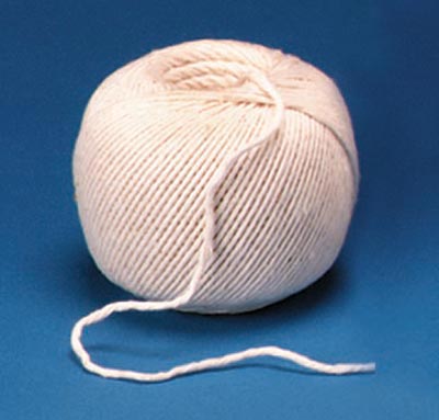
If you aren't going to visit every checkpoint, make a marked string to measure out your route.   Assume the maps have a scale of 1:25000.  Before the Street Scramble, get a piece of string that's a few feet long, and mark off a starting point and 'miles' from the starting point.  Every 5th mile, use a different colored marker.  At the event, after you have a preliminary route, measure it out with your string as best you can; you won't get it right, but that's okay because you'll probably have to improvise at some point anyway.  Verify that the map scale is 1:25000 (it's usually a multiple/divisor, so the math won't be too hard it if isn't), and assume your measurement was an underestimate.  If your route is too short, add checkpoints.  If it's too long, subtract.  Either way, you should make contingency plans.  Where do you expect to be after 45 minutes?  1 hour?  2 hours?  Have a plan in case you're way ahead or way behind.

One final consideration is what to do with the collection of checkpoints near the start/finish.  These are usually low-valued, but there are enough of them that you should not skip them altogether.  My advice is to get a few as you start, in the general direction that you're heading, making extra sure to get any 30, 40 or 50 point checkpoints.  Leave the rest.  Some you will get on the way back to the finish.  It's good to have a few that you can pick up if you find yourself with an extra 5 minutes, but that you won't feel bad about if you skip them.

If you're part of a team, have one person plan the overall route while the other looks at routing between checkpoints.  The routing on some legs will be obvious.  Others might be tricky.  One easy way to mess up is to miss a turn.  The map you are given typically will not name every street.  If you need to, for example, take a left after 3 streets, it's better to find out the name of the street you want to turn on and write it in on your map.  AAA maps can help with street names, but local bike maps are often better.  If you have time, you can also use Google maps to do your routing for you, but you won't have time to do this for more than a few checkpoints.

Before you go, review where the first few checkpoints are and what their questions and answers are.  When you're on the course, use your time between checkpoints to do the same (but be sure to pay attention to traffic!).  Stoplights are a good place to review where you're going next, and to write down answers to checkpoints you've already visited (and make sure you didn't forget to mark any answers).

Before you turn in your answer sheet at the end, if you have any extra time, take the time to review all your answers.  You may find you forgot to answer a question you were sure you'd already marked.

Up and Coming

Make like Tom Sawyer on Union Bay June 28

See last week's post for more detail on the events with a minimal description.
  • Gig Harbor Street Scramble - May 26, free.  I've been talking about this for umpteen paragraphs now.  Pay attention. 
  • The Seattle Public Library will be hiding 1000 books around town, in connection with their Summer Reading Program.  And you still have to wait until June 1 to find out more.
  • Hood Hunt Moses Lake - June 2.  
  • Long O - June 2, Moses Lake.  
  • Kid and Goat O - June 3, Fishtrap Lake.  
  • First Thursday Adventure Run - June 7, Green Lake.  
  • 9-5 Scavenger Hunt -  June 16-17, Gasworks Park.  9pm to 5am, you night owl you.
  • Evening Orienteering - Wednesday, June 20, Kelsey Creek Park, Bellevue.  I checked with the organizers, and June 20 is the correct date, despite what it may say on their website.
  • Run26 Third Thursday Adventure Run - June 21, Mill Creek. 
  • Girls of Summer Alleycat, pt. 2 - June 23, I-5 Colonnade Park.  
  • Issaquah Street Scramble - June 24.  If you're really hardcore, you'll bring your swimsuit in case it's faster to swim across Lake Sammamish.
  • BEAST race #3 - June 28, UW Waterfront Activities Center.  Start off with canoe orienteering (the WAC rents canoes), come back after a break for the running/biking section.  This is the most beginner-friendly of the BEAST races, in the most urban locale and near the solstice, so you get the most daylight.  In other words, a great first adventure race.


Friday, May 18, 2012

Armchair Treasure Hunts (or, Make thousands of dollars by working at home!)

I was all set this week to write about the fiascos and disasters of the PuzzleHuntContest world, when one of my Google alerts brought up this:

$1 Million Dollar Treasure Hunt Making a Difference in Breast Cancer Research 
It seems someone has hit upon the idea of using an Armchair Treasure Hunt as part of a fundraising campaign.  This particular hunt, labeled The World's Greatest Treasure Hunt (which I shall abbreviate TWGTH), requires you to buy a book (or 2, or 3) for a hefty price, most of which goes to a breast cancer research charity.  The book has 12 chapters, each referencing a famous hidden treasure, each yielding a prize, and each, apparently, written by a different puzzlesmith.  After all 12 prizes have been found, you can start searching for the grand prize, a golden eagle.  The winner of the first prize, Roger Lintott of the UK, solved the chapter based on the D.B. Cooper story, and found his silver eagle prize at the base of the Space Needle.
Careful with that thing; it's worth $37K
Chapter 2 is about the Maltese Falcon, and centers on San Francisco.  Before you go digging at the base of the Golden Gate Bridge, you should know that the other treasures probably aren't out there.  It seems the people behind TWGTH have learned a lesson or two about past fiascos, thus tying neatly into my original topic.  Lesson one:  NO DIGGING!  Roger figured everything out online, submitted a solution online, and, once it was verified, was flown out for a little Amazing-Race style rush through famous Seattle landmarks to find a certificate 'buried' under a paper X:
Not found under the '.com'
You can find more pictures on TWGTH's Facebook page.

Let's flashback to the first armchair treasure hunt book.

Masquerade:  The first of its kind, in more ways than one

It all started in 1979
Author/illustrator Kit Williams created a genre with Masquerade, a children's book that was also a hunt for real treasure:  a jeweled gold hare that Williams had buried somewhere in Britain.  Hundreds of thousands of copies were sold, and dozens of places across Britain were dug up, most without permission.  If you couldn't make it to Britain on the basis of a hunch, you were invited to send your solution to Williams by mail, and he would let you know if you were correct (presumably at that point you would buy your plane ticket to riches and glory). The hare was found about three years later by Ken Thomas, and numerous follow-up books were written with similar buried prizes.  I don't think any sold as well as Masquerade, but there are still Armchair Treasure Hunting societies out there.  The most popular website for discussing these and other treasure hunts is tweleve.org.  

This is all well and good, and apart from the damage done to places in England like Haresfield Beacon, no harm no foul, right?  Not exactly.  It turns out 'Ken Thomas' was a fraud, a pseudonym for Dugald Thompson, whose business partner John Guard's girlfriend was Kit Williams's ex-girlfriend.  She knew approximately where the hare was buried, Guard and Thompson found a likely location, and, after some fruitless searching with metal detectors, Thompson sent Williams a note with a drawing of their best guess.  Williams, per his agreement, wrote back saying they had the right location.

To complicate matters, a pair of schoolteachers had solved the puzzle correctly, and were digging in the correct location.  But the puzzle was based on a monument's shadow at the equinox, Williams had slightly miscalculated the location, and they were digging a few feet off.  Thompson happened to be around when they were digging and noticed that they had unknowingly dug up the container with the treasure and left it in a pile of dirt.  Thompson took it for his own and contacted Williams again as 'Thomas' to announce that he had found the hare.  The skullduggery did not come to light until 1988.  You can read the whole story.

Once is not enough

The hare's final fate:  bankruptcy auction

Masquerade directly bred one more scandal when Thompson used the prize as the basis for a computer puzzle game, where the hare was to be the grand prize.  The puzzle was never solved (and was allegedly unsolvable, with the hare as bait to get you to buy the game).  The hare was finally sold by Sotheby's.

The most popular follow-up book in the US was Treasure: In Search of the Golden Horse (full disclosure:  I once got it as a birthday present).  The Golden Horse was never found, the contest expired in 1989 and all prize money was donated to charity.  Seven months later, the puzzle was supposedly solved and the solvers dug up a consolation prize in the Colorado.  But their solution did not appear to make sense, and it is widely conjectured that the promoters made a number of errors that led to the puzzle being unsolvable.  To save face, they directed the 'solvers' to the spot in Colorado.

With this background of deception on all sides, it's not surprising that TWGTH comes with a long list of Official Rules, Terms and Conditions, and a Liability Disclaimer, and the promoters have come up with an elaborate series of safeguards to guard against someone winning the puzzle without actually solving the puzzle.  On the other side of the coin, potential solvers are wary of spending $30-$50 on a book featuring a puzzle that isn't solvable.  In this respect, breaking up the puzzle into 13 separate puzzles was a smart idea.  The fact that someone has solved the first puzzle should give you hope that the others are solvable as well and there are actual prizes to be won.

Math is hard, let's go shopping!

Optional equipment

So, should you go out and buy this book?  The first puzzle took over two years to solve (the book was released in late 2009 and you were not allowed to solve the puzzle until early 2010).  If you look at the solution, you might get an idea why. Also, poke around the message boards on tweleve.org to get some idea as to what others think about how difficult (and 'fair') the puzzle was.  I read some gripes, but there always seem to be sour grapes after someone finally wins.

To help speed things up, the promoters have taken to giving out occasional clues on TWGTH's Facebook page.  (Apparently some of those gripes had to do with these clues so, as always, be careful...)

What I'm wondering about, though, is the fundraising aspect of this endeavor.  The promoters claim this is a part of raising $100 million for breast cancer research, and I'm dubious they will come close.  The book has no publisher or distributor (which allows more of the profits to go to charity, but still...).  The first I heard of it was the aforementioned Google Alert.  Even after the event yesterday, the only news reference I can find to it is in Albany, NY.  Despite all their efforts, it seems that the mania for armchair treasure hunts has long since passed.

Which I guess means there's more out there for those of us that try.

Coming Attractions

This could be you!  (Photo: Sean Sweeney)

See last week's post for more detail on the events with a minimal description.
  • UW Amazing Race - May 19, 11:30-1.  Is everything happening today?  Seems like it.  Teams of 2 (who may or may not need to be UW Students) run around the U-District for some pretty good-looking prizes.  Can you still sign up?  Answer is foggy, but it's worth a shot.
  • Dumpster Champ - May 19.  Alleycat
  • Seattle Challenge - May 19.  The first of the 'Amazing Race' style events of the year.  
  • Battle for Seattle - May 19.   Photo Scavenger Hunt, UW Students only.
  • Evening Orienteering - Wednesday, May 23, Robinswood Park, Bellevue.  Orienteering + free food.
  • Gig Harbor Street Scramble - May 26, free. 
  • The Seattle Public Library will be hiding 1000 books around town, in connection with their Summer Reading Program.  Want more info?  Tough.  Wait until June 1.
  • Hood Hunt Moses Lake - June 2.  
  • Long O - June 2, Moses Lake.  
  • Kid and Goat O - June 3, Fishtrap Lake.  
  • First Thursday Adventure Run - June 7, Green Lake.  
  • Evening Orienteering - Wednesday, June 13, Kelsey Creek Park, Bellevue.  This may have been moved to the 20th.
  • 9-5 Scavenger Hunt -  June 16-17, Gasworks Park.  That's 9pm to 5am, folks.  Caffeine stops and breakfast are provided to help keep you rolling (and send you on your way back to your bed to sleep it off).  Or you could do like my friend Dave, who always shows up at the beginning, rides home to sleep, then comes back at 5am for the breakfast.  Form a team if you're serious about winning, because, apart from the late night time frame, this is a classic scavenger hunt where you need to acquire as many things as possible from a long list.
  • Run26 Third Thursday Adventure Run - June 21, Mill Creek.  A lot like the First Thursday Adventure Run, but two weeks later and (I hear) more disorganized.  Still, lower attendance means you're more likely to win!
  • Girls of Summer Alleycat, pt. 2 - June 23, I-5 Colonnade Park.  Part one was last summer, and you didn't miss much, except for one of the best bike races of the year.  Women only.  Guys, you can help out at checkpoints (last year, they had, among others, 'prom pictures with your bike' and a race on Big Wheel-sized trikes -- see above).  Expect awesomeness.
Cooped up with a cold?  Ponder this list of items to obtain, from the 2012 University of Chicago Scavenger Hunt.

Friday, May 11, 2012

Geocaching and Letterboxing (or, I did something for a couple of days, and now I'm an expert)

Relevant literature

There's a bit of a lull in my PuzzleHuntContest schedule, so I decided to take my own advice and try out geocaching and, while I was at it, letterboxing.  The two are very similar, at least when you're looking in the University District. Both involve following clues to find boxes that other people have hidden in (usually) public locations.

Geocaching uses the latitude and longitude of the 'cache' as its main clue, a technique that was only made possible in 2000 when civilians were allowed to access precise latitude/longitude via Global Positioning System (GPS) devices (prior to this, GPS technology was considered classified and civilians could not buy devices that gave precise data).

Letterboxing is far older, dating back to 1854 when a guide in Dartmoor, England left a bottle out on the Moors for people to leave a visiting card in.  This grew into a practice of leaving postcards and letters, which would eventually get mailed (or letterboxed, as the Brits might say).  Nowadays, letterboxers leave a rubber stamp and a book in their boxes.  When you find a letterbox, you (having been armed with a stamp and book of your own), stamp your own stamp in the box's book, and use the box's stamp to stamp your own book.  Supposedly, this makes letterboxes more artistic (you can carve your own stamps), but there's no inherent reason why these stamps need to exist.  Geocaching caches can have collections of trinkets in their box (if you take a trinket, you're supposed to leave one as well), but they also have logs to sign.  The absence of the stamp means geocaches can be much smaller than letterboxes, which allows them to be hidden in many more places.  I would suspect these distinctions will become less important over time; there's no reason you can't leave trinkets in letterboxes (I found one that did) or stamps in geocaches, or nothing at all in either.

In an urban environment, there isn't much difference between finding a geocache and finding a letterbox.  Geocaching uses GPS coordinates, but they aren't precise enough to pinpoint an exact spot, so you can use a smartphone or just look them up on Google Maps to get the approximate location and then do a search once you get there (individual caches often have a hint to help get you to the final place, e.g., 'behind the tree').  Letterboxes, on the other hand, have no GPS constraints, so their clues can take any form from the obvious ('take the right fork, look between the boulder and the log') to a cryptic riddle.  Many geocaches also use puzzles (Sudoku, riddles, YouTube videos, whatever), but the end result is almost always a series of numbers that you turn into GPS coordinates.  Again, there is no real reason why a type of clue used for a letterbox can't be used for a geocache, and vice versa.

The chief difference I found between the two was the size of the community.  In Seattle, there are more geocaches than letterboxes (I imagine this is reversed in other locations).  This can make letterboxing more frustrating than geocaching.  There are fewer things to find and there are fewer things to find that are at the right difficultly level.  Most annoying is that caches and boxes are continually being stolen, disturbed or otherwise lost, and only get renewed/replaced when someone notices and fixes the problem, so a smaller community means a greater chance that the letterbox you go to look for just is not there.  Still, that's more of a caveat than a warning.  Find a list of letterboxes and geocaches near your location, and go out to look for both.

Getting started with Letterboxing

Letterboxing starter kit
Before you go, you should have a pen/pencil (to write your name in the letterbox log), a logbook (I just used the printout of the directions to the first box I tried to find, but after a few stamps it's getting pretty full), a rubber stamp and an inkpad, and a reasonable compass.  The inkpad can be any color or multicolored.  The stamp should be of something you think represents you (so probably not 'Final Notice'.  I dunno, maybe that works for some of you).  The compass is primarily used for clues that have bearings in them.  E.g., 'Look to 135', which means line up the red arrow with 'N' on your compass and look in the direction of '135' on your dial.  If you really don't know how to use a compass, try this.  Note that not all letterboxes use compass bearings as part of the clue, so a compass is not always necessary.  Also, with a small bit of local knowledge (Basically, which way is magnetic north?) and the ability to figure out where a bearing like 135 is (hint: magnetic SE), you can sometimes fake it.

You'll also want to think up a 'trail name', like Scooby and the Gang or Joffrey E. Baratheon, Super Genius, or q?87yrz.  Because, you know, 'Greg Barnes' is too pedestrian, or the North Koreans are going to track you down and start extorting classified letterbox information from you, or something.  Whatever, just go with it.  My advice:  register at a geocaching/letterboxing website and use your username as your trail name.

Speaking of websites, the easiest way to start is to go to a website.  I tried letterboxing.org first, but most of their Seattle boxes seemed stale (as in, they had not been visited recently).  Apparently all the cool Seattle kids are hanging out at AtlasQuest.com, possibly because it's run by a person in Seattle.  If you're just starting out in Seattle, I'd advise using AtlasQuest to look for letterboxes to find.  All the sites I found allow you to make a geographic search.  You can often tell just by the name of the letterbox whether it's close by; other times you have to read the description.

I started out with a box that was inside the University Heights Center, because I could easily go there over lunch, it seemed easy to find, and it had been found recently, so it was probably still there.  It was velcroed under a bench in a hallway where a bunch of kids at a private school were passing by on the way to and from recess, so this presented a bit of a problem, as you're supposed to retrieve and replace the box without anyone else seeing, lest they decide to investigate and end up taking the box home to keep.  I used the oh-so-clever "I dropped something on the floor" trick and it seemed to work fine.  I didn't employ any caution once I had the box in my hands, since I figured someone sitting down, looking at a book and making a few stamps is fairly unremarkable behavior in the U-District (the old "I'm an art student" trick).  And then I dropped something on the floor again, reattached the box, got up and left.  And then proceeded to worry for the next 10 minutes that I hadn't sealed the container properly or got enough velcro attached, and it would all come spilling out.  Still, Success!

Armed with my newfound expertise, I decided to go out after work to get a few more letterboxes and my first geocaches.

Geocaching without a GPS

From the UN-mandated Office of Geocaching

Theoretically, you need a GPS device to find geocaches, but Google Maps works pretty well in the city where there are plenty of landmarks.  Find the coordinates, plug them into Google Maps, make yourself a crude little map as to where it is (corner of 43rd and 17th, east sidewalk, lined up with the end of the fence).  As I said above, the GPS coordinates used in geocaching are not exact enough to pinpoint the exact spot, so you're going to have to search around anyway.  However, if I were in a more rural or wilderness setting, I'd insist on having a GPS-enabled device at hand while searching; they are typically not as exact as Google Maps, but it's a lot harder to pick out landmarks from a satellite view of the middle of the woods or a grassy meadow, so you'll need GPS on the spot to find the best place to start searching.

Geocaching.com calls itself the 'official' site of Geocaching, which seems a little grandiose to me.  But they are also run by people in Seattle and seem very popular, so you should start there.  They have a zipcode search and a distance search, which is good, because a citywide search of Seattle would probably yield an absurdly large number of caches.  Their search listings also (by default) highlight in green the caches that are best suited to beginners.  I'd start with these, but I'd also tackle a puzzle cache as well (this is a PuzzleHuntContest blog you know. I'll get to the Contest part later.).  A puzzle cache, as a rule, has  GPS coordinates that are bogus but close enough so that the website's geographic search gives you the right general area.  You solve a puzzle that yields the series of numbers that allow you to determine the real coordinates.  For example, the first cache I found started with a Sudoku puzzle where some of the squares were lettered A through F.  Once you solved the puzzle, you plugged the corresponding number into this formula to yield the coordinates:  
N 47° 39.AB(C+4)
W 122° 18.D(E-1)(F+5)
Puzzles can range from the simple to the extremely difficult, and come in a wide variety of formats, but almost always yield numerical answers.  Try a few out and you'll get the feel for it.

If you're heading out without a smartphone or some other way to surf the net, you're going to want to get a hardcopy of the page for the cache.  First, because you'll want to read the description if you can't easily find it, to make sure you think you're in the right place.  But also because the GPS coordinates are too crude, and you'll frequently need a hint.  Geocaching.com puts the hints in rot13 on the cache page, along with the key to deciphering them, so you'll have the hint available but basically unreadable unless you need it.  You probably don't want to print out the logs (the notes people leave on the website when they find the cache), as they can give it all away and you can end up going through reams of paper if you print out the pages for a few popular caches.

Finally, for both geocaches and letterboxes, pay attention to when the item was last found.  If it was a few days ago, you can probably assume it's still there, but if it's been over a year, you might not want to spend a lot of time looking for it.  The first time you go out, you probably only want to look for things that have been found in the last month or so, unless fruitless searching is one of your favorite things.

Eureka!


I blame David "Seattle mayoral candidate" Stern

I went searching after work, and the first stop was the geocache with the Sudoku clue.  Google Maps put the GPS coordinates in the middle of a walkway, and that seemed very unlikely, so I deciphered the hint.  After examining a few of the more prominent signposts and plants near that section of the walkway, I knew what the hint meant, but still didn't know where to look.  It took about 15 minutes to find the object the hint indicated, and it was about 40 feet from the coordinates, so there was something a bit screwy going on.  And still, I had not found the object.

As I've said before, I'm not very good at finding things hidden in plain sight; it took me 10 minutes to find a Canlis menu when I knew exactly which plane it was near in the Museum of Flight.  I walked right by the rather obvious Emerald City Search medallion last month (too busy looking at the ground).  So I considered this good training for future PuzzleHuntContests.  The cache was definitely in some plants, and I knew it was 'micro' sized (the size is listed on the geocaching.com entry for the cache; another reason to print out the webpage), so I guessed it would be a tiny plastic or metal tube.  After groping around in a few piles of wet leaves, I found what is known as a Bison Tube.  It looks a little bit like a miniature Kleen Kanteen:
Geocaching containers, not bovine anatomical parts
They come in larger sizes, by the way, and are named after the company that builds them.  Inside was a rolled up piece of paper to record your name, and nothing else.  I put my trail name and date on the next spot on the log, resealed it, then hid it back under the same wet leaves.

The next cache I found was also in a bison tube, although it had a strong magnet attached to it (so it could be stuck to a piece of metal).  My last geocache of the day was in a large Tupperware container behind a tree, on a somewhat busy road with no sidewalk.  3 for 3.

I moved on to a letterbox near the Ronald McDonald House on 40th Ave NE, where I found something interesting.  In addition to the stamp and logbook, there was a tiny film cannister labeled "P-Patch Hitchhiker Series", containing its own little rubber stamp (of a beet) and logbook.  I guessed that this was a letterbox that was supposed to 'hitchhike' from one letterbox to the next, so I took it with me.  I was right, but even if I hadn't been, it would have been simple for me to put it back the next day.  Both letterboxes and geocaches have various twists like this, and the websites have pages that explain the proper thing to do with them.  I'd say if you come across anything strange, look on the website for guidance.  If you don't have Internet access, don't do anything you can't undo.  If you think you're supposed to take something with you, and you can put it back easily if it turns out you're wrong, go ahead and take it.  But be sure to look it up when you get home and fix your error if you're wrong.  A number of items are supposed to be rehidden under certain conditions, so if you aren't prepared to rehide the item under these conditions, you should put the item back ASAP.

Summary

If you like Hunting and Puzzling, you should try geocaching and letterboxing.  They're easy to get into, and can be tried anytime and almost anywhere.  Lack of GPS should not deter you, especially in an urban setting.  Also, if you have a smartphone, it probably has good enough GPS, and there are a number of apps you can get to make the whole experience even more seamless and fun.  For example, there's an app that uses your phone's position to tell you geocaches that are nearby, and can keep track of which ones you've already found.

If you have kids, you should definitely try these activities, as a number of caches and boxes were hidden with  kids in mind, and as a rule kids like searching for 'treasure'.

If you have dreams of finding a Canlis menu or Emerald City Search medallion, searching for caches/boxes is probably the best practice you can get for the actual 'finding'.

Use the websites to communicate with your fellow searchers.  You don't need to chat with them endlessly, but they will tell you if a cache/box is missing or lost, and you should return the favor if you can't find one.

If you want the Contest aspect of a PuzzleHuntContest as well, and are in Seattle, your best bet is to use geocaching.com.  For each contest, there is the FTF (first-to-find) contest, won by the first person to find a cache.  There are other achievements to unlock as well, such as caches that you can't officially log (find) until you have logged other caches.   See for example, the Peace Sign Series.  The prizes are basically only fame in the geocaching.com community, but these are definitely contests.

Finally, if you want to design your own puzzle/hunt, placing a geocache or letterbox is probably the next step up from making a treasure hunt for your kids.

Coming up next...

PuzzleHuntContests in the next month or so.

  • Port Gamble Rogaine - May 12, Port Gamble.  I think it's too late to register now.  Look at that weather forecast, and weep at your lack of planning.
  • BEAST race #2 - May 17, Lynnwood.  Adventure race in Lynnwood.  Hint:  If you go down to the Puget Sound, you're gonna have to make your way up eventually.  Hint 2:  You're gonna have to go down to the Sound.
  • Dumpster Champ - May 19.  Dumpster diving and bike racing.  Two great tastes that go great together.
  • Seattle Challenge - May 19.  The first of the 'Amazing Race' style events of the year.  The prize:  Real Cash Moniez!
  • Battle for Seattle - May 19.   Photo Scavenger Hunt, UW Students only.  With only 2 weeks of classes left, this is a prime opportunity to avoid studying.
  • Evening Orienteering - Wednesday, May 23, Robinswood Park, Bellevue.  Orienteering + free food.  The only thing that will stop me attending this is another presidential visit.
  • Gig Harbor Street Scramble - May 26, free.  Once you've made it to Gig Harbor on the Saturday morning of a 3-day weekend, you're legally obligated to go camping somewhere.  Just warning you.
  • Hood Hunt Moses Lake - June 2.  Speaking of camping...
  • Long O - June 2, Moses Lake.  Sand Dunes!  Bring extra socks.
  • Kid and Goat O - June 3, Fishtrap Lake.  This area (channeled scablands) is amazing, and you should go there.
  • First Thursday Adventure Run - June 7, Green Lake.  Seriously, all you have to do is walk a block and you're entered to win thousands of dollars in prizes.  Why aren't you doing this?
  • Evening Orienteering - Wednesday, June 13, Kelsey Creek Park, Bellevue.  This may have been moved to the 20th.

Friday, May 4, 2012

The Promise of Summer

Summer Summer Summertime
May Day used to be considered the beginning of summer, and (at least this year) it seems those old pagans might be on to something.  Even if the rain doesn't hold off, the worst La Nina or onshore flow or persistent Arctic trough, or whatever it is Cliff Mass is going on about these days can't prevent the sun from setting before 8, 8:30 or (eventually) 9pm, and when the sun is up that long, it's bound to be warmer come 3pm, 5pm or 7pm.  It's time to start thinking about PuzzleHuntContesting in summer.

Summer in the Northwest means planners and hunter/contesters get more bold.  Events start later (or sometimes, much earlier), are held in further-flung locations, and include more and varied twists.  The companies that charge large entry fees (and, to be fair, award large prizes) wisely hold off their races until the summer months when people won't be scared off by the threat of rain.  Local entities like Seattle Parks and Recreation feel confident putting on family-friendly competitions in August that could be disastrous in March.  To help you with your summer planning, here's a rundown of the many PuzzleHuntContests you can participate in.

The Great Urban Oyster Race Challenge

An inspiration to race designers everywhere

After The Amazing Race debuted, various companies sprung up with various races meant to give folks the Amazing Race experience without actually going very far.  Teams are required, you have to run (or sometimes bike or bus) around solving puzzles and performing silly and/or semi-embarrassing challenges.  The entry fee is typically pretty high ($50-$100 or more for a team, although you can sometimes get discounts via Groupon or similar services), but the prize money is also fairly high.
The past few years, Seattle Parks and Recreation has put on a 'Family Amazing Race' in Magnuson Park in August sometime.  We will know more when the summer schedules come out.

Orienteering

Follow the red lines
Orienteering is the sport of navigation, usually on foot.  There are two local orienteering clubs, Cascade Orienteering Club (COC, larger, based in Seattle) and Sammamish Orienteering Club (smaller, based on the Eastside), both of which put on events throughout the year in the Puget Sound region.  During the winter, they hold meets at locations ranging from Mt. Vernon to Olympia (basically, anywhere you could rationally drive by the typical meet start time of 10am).

But come summer, the gloves come off.  Sammamish mixes it up by holding meets in Eastside parks on weekday evenings, with a hot dinner provided.  Cascade opts for longer courses in more distant locales, and usually also includes one canoe orienteering race.  I like canoe orienteering, but I'm terrible at it, usually ending up cutting through lilypads (don't do this) or going the wrong way around an island or two.  See the June BEAST race if you want more canoe orienteering.

If you find yourself attending more than a couple of these or similar events, join one of the orienteering clubs, as membership in any club gets you a discount on all events for year, which will pay for itself quickly.

  • Score O - May 6, Shoreview Park.  In a Score O  (or rogaine) format, you try to find as many checkpoints as you can in a time limit.  Start at 10:30am if you want to go for 90 minutes, 10:30 or 11:15 if you only want to do 45 minutes (and show up earlier for registration).  There will also be a standard beginner course (where you must visit the checkpoints in order).
  • Port Gamble Rogaine - May 12, Port Gamble.  Again, find as many checkpoints as you can.  But this time you can be out for 2, 4, or 6 hours, and you can ride a bike (or do half foot/half bike).  Port Gamble is more of a wilderness experience than the usual orienteering parks, but still not so distant or wild that you have to go through a lot of preparation to do it.
  • Evening Orienteering - Wednesday, May 23, Robinswood Park, Bellevue
  • Long O - June 2, Moses Lake.  In the Sand Dunes area around Potholes Reservoir, followed by
  • Kid and Goat O - June 3, Fishtrap Lake.  Fishtrap Lake is in the channeled scablands near Sprague, a beautiful location.  I believe Kid and Goat is like a classic course, except everyone starts at once, and you're allowed to skip a small number of controls.  So you end up following others, until you (or they) decide to skip one.  Make an Eastern Washington weekend of it; the weather should be nice for camping near Moses Lake or Sprague.
  • Evening Orienteering - Wednesday, June 13, Kelsey Creek Park, Bellevue.  The website says 'Search and Rescue O', but I have no idea what that means.
  • Long O - June 30, Salmon La Sac.  Make a weekend of it at what (I hear) is one of the most beautiful camping locations in the state.
  • Evening Orienteering - Wednesday, July 18, Big Finn Hill Park, Kirkland.  With a big barbecue aftewards.
  • Paddle O - August 5, UW Waterfront Activities Center.  Rent a canoe, or bring your own (kayaks are okay as well).  Don't forget the sunscreen, and watch out for thick lilypad patches and swans (those guys are nasty).
  • Evening Orienteering - Wednesday, August 8, Luther Burbank Park, Mercer Island.  If it's sunny, bring your bathing suit and have a swim afterwards.
  • National Orienteering Day - September 15, Woodland Park.  Very beginner friendly.
  • Salmon Days Orienteering - September 22 or 29, Lake Sammamish State Park
  • Three15er 24 Hour Rogaine - September 29-30, Naches, WA.  Shorter options will surely be available.  3, 6 and 12 hours would be my guess.
There are more events even farther afield (in BC, Oregon, and beyond) listed on the COC website, as well as some events that are being planned but have yet to be finalized enough to go on their calendar.


 Urban Orienteering

You'll never look at a utility pole the same way again
If you do orienteering in Seattle, compasses are largely pointless, and you really aren't going to become truly lost, so these events function more as an in-city scavenger hunt.  Basically, you get a map with a number of locations, and you try to visit as many as you can within a set period of time.  Street Scrambles are the most prevalent these days, but they were created as warmup events for the (potentially) marathon Night and Day Challenge.  On the other end, Hood Hunts are a shorter, lower key version that typically take place over 1 square mile.  

Note:  The following Street Scrambles and Night and Day can be done on bike or foot, except for the Fremont Oktoberfest event, which is foot only.

  • Hood Hunt Sunset Hill - May 5 (Saturday), 10am.
  • Gig Harbor Street Scramble - May 26, free.  Cross the Tacoma Narrows Bridge to a nice little town that puts on this free event to help get its residents in shape (and to attract out-of-towners across the Tacoma Narrows Bridge).  Hint:  pay attention to the contour lines; the gentlest slope out of downtown is to the north.
  • Hood Hunt Moses Lake - June 2.  In conjunction with other Cascade Orienteering Club events the same weekend.
  • First Thursday Adventure Run - June 7, Green Lake.  First Thursday runs are a unique monthly race that's sponsored by Road Runner Sports at Green Lake.  There's only one (gigantic) map with the checkpoints, which is revealed at 6pm.  Each checkpoint gives you raffle tickets, and at 7pm you return for the raffle which features thousands of dollars in prizes.  If that's not enough, there is cheap beer, and the chance to win more prizes at the after party.  In case you're wondering, the $25 event shirt (which gets you double raffle tickets) is worth the investment if you want to win a prize.  But it's also okay to just walk to a few checkpoints and enjoy the cheap beer.  'Like' Road Runner Sports on Facebook for reminders and to see the monthly 'secret' checkpoint.
  • Issaquah Street Scramble - June 24.
  • First Thursday Adventure Run - July 5, Green Lake.
  • Seattle Night and Day Challenge, July 28-29.  Basically a gigantic Street Scramble that covers most of Seattle and starts at 4pm, with options for 90 minutes, 3 hours, 7 hours, and 16 hours.  16 hours gets you a real 'night and day' experience.  I prefer the 7 hour option, which still gets you some night, but with less of the hangover after you pull an all-nighter.  If you clear the course (I almost did it once; forgot the Locks closed at 9pm, dammit), you'll go around 70-80 miles.
  • First Thursday Adventure Run - August 2, Green Lake.
  • Bainbridge Street Scramble - August 18.  I assume this will be kind of like the Chilly Hilly, except with more checkpoints, better weather, and fewer people who fall over at the bottom of the hill because their derailleurs rusted out over the winter.
  • First Thursday Adventure Run - September 6, Green Lake. 
  • Fremont Oktoberfest Street Scramble - September 23.  Foot only, with a course designed by Yours Truly.  I like coming up with a theme for my checkpoints; the great thing about Fremont is that I can always find enough checkpoints to make the theme work, since Fremont is full of random crazy details everywhere you look.
More Hood Hunts are planned; you could even design one yourself in your favorite Hood if you wanted.  Plus you can always go back and do old ones (the maps and questions are online), although some of the checkpoints may have vanished.


Bike events

Bad idea, or terrible idea?


This year Seattle is sending a couple of riders to the North American Cycle Courier Championships (i.e., to join a bunch of uncouth bicycle messengers raising havoc in another city).  As fundraisers and warmups, a group of folks have been putting on alleycats (checkpoint bike races) all year, with progressively crazier themes:  Staircases, Disabled bikes, and (the latest) Dumpsters.  Reward such creativity by attending one of these; prizes are usually surprisingly good.

On a more permanent basis, Go Means Go has been putting on bike events around town for four years now, including the pre-Easter Resurrection Race and an all-night Scavenger Hunt on the longest (weekend) night of the year.
  • Dead Bike Drag - May 5, 1pm, Denny Park.  Teams of two, and one of your bikes gets disabled by having its chain removed.  I hear the course is only about 3 miles long --- sounds like a good spectator sport.
  • Dumpster Champ - May 19.  This could be the most gloriously disgusting idea ever - an alleycat where you have to dumpster dive at the checkpoints.  Conveniently, I can't participate.
  • 9-5 Scavenger Hunt -  June 16-17, Gasworks Park.  That's 9pm to 5am, folks.  Caffeine stops and breakfast are provided to help keep you rolling (and send you on your way back to your bed to sleep it off).  Or you could do like my friend Dave, who always shows up at the beginning, rides home to sleep, then comes back at 5am for the breakfast.  Form a team if you're serious about winning, because, apart from the late night time frame, this is a classic scavenger hunt where you need to acquire as many things as possible from a long list.
  • Tour de Watertower - July 22.  A punishing race to all of Seattle's high hills ('cause that's where the watertowers are, baby).  Since the towers and the starting/ending points are widely known, this race favors speed and endurance over route planning.
I assume there will be even more alleycats announced as the weather gets better.  See also the Urban Bike Adventure, above.


Adventure Races 

Racing adventurously, TRIOBA style
Classic Adventure Races feature biking, running and paddling out in the wilderness somewhere, often for 24 hours or some similarly exhausting period.  The TRIOBA race is like that; BEAST races are at the other end of the scale.  No paddling at BEAST races (except the June event), no wilderness (unless you think Lynnwood is wilderness) and meant to be done in an evening.  Make no mistake, though, you could end up dehydrated and exhausted on a gravel trail in the suburbs if you don't know your limits, so you should have some racing experience under your belt, or at least take it easy the first time out (says the guy who barely managed to bike home from Newcastle a couple of Augusts ago).


  • BEAST race #2 - May 17, Lynnwood.  To make up for the fact that there is no paddling, the BEAST races usually include a 'surprise' challenge like croquet, or disc golf, or the surprisingly-difficult-after-you've-biked-10-miles Winnie the Pooh puzzle.  Otherwise, expect a few miles of running and 10-15 miles cycling on some suburban trails you probably didn't even know existed.
  • BEAST race #3 - June 28, UW Waterfront Activities Center.  Start off with canoe orienteering (the WAC rents canoes), come back after a break for the running/biking section.  This is the most beginner-friendly of the BEAST races, in the most urban locale and near the solstice, so you get the most daylight.  In other words, a great first adventure race.
  • TRIOBA 24 Hour Adventure Race - July 7, Cougar, WA.  "There will be 15-25 miles of flat water paddling, 50-75 miles of biking, and 20-30 miles of trekking and trail running."  I assume this is a great experience if you know how to navigate in the backcountry, but for your own safety, you should stay with tamer events if you do not.
  • BEAST race #4 - August 7, Issaquah.  Did I ever tell you about the time I was on a BEAST race in Maple Valley and the course got me so confused I ended up going to the other end of the Cedar River Trail before I realized I was heading east instead of west?  Bring a compass.
  • TRIOBA Sprint Adventure Race - August 18, Ellensburg.  20-30 miles of biking, 5-15 miles on foot, no paddling, 5-10 hours total.  If you're looking for the next step after BEAST races, this would be a good place to start.

Miscellaneous

  • Run Brain Run - Ongoing public scavenger hunts at Pike Place Market (first Saturdays), Central Library (third Saturdays) and Seattle Art Museum (first Thursdays).
  • Battle for Seattle - May 19.  Photo scavenger hunt, but you have to be a UW student to participate (and half your team has to live in the dorms).  It's put on the RHSA, that's why.
  • My hunt - The smart money says in June, I will have got my act together and have another puzzle hunt ready.  Featuring free entry and prizes that were deliberately chosen to not be worth cheating for.
  • Bikemania - July 19, Magnuson Park.   As part of the Cyclefest put on by Cascade Bicycle Club, there will be a treasure hunt, presumably just for kids.  But you could ride along with your kids.  You know, to 'help'.
  • Gumshoe 5K - August.  A charity event where you walk around Greenwood and solve a puzzle using clues you find along the way.
  • Diamond Dash - August, usually.  Free entry.  Prizes:  a local jeweler puts up a ring purportedly worth something like $6000.  2nd prize is also nothing to sneeze at.  You run around a small area downtown solving clues using a mobile phone application called SCVNGR
  • Canlis - If I were a betting man, I'd say we see another Canlis contest before the summer is out.  See their 60th anniversary menu hunt or last year's key hunt if you don't know what I'm talking about.  And join the Menu Hunters Anonymous Facebook community if you want to stay in the loop.

That should be enough for now.  Let's summarize for the next month

Required gear for Letterboxing.  Maybe.
This week's wildcards;

The Run Brain Run events (see above) are every other weekend (including this Saturday).

A company called Search Tempest is running an Internet-based contest they call a scavenger hunt; I don't
know about that; you just find and submit strange eBay listings.  Judge for yourself.

I just stumbled upon letterboxing, which sounds a lot like geocaching, but with more elaborate (and not usually GPS-based) clues.  More investigation is required.

Let me know if you know of any other PuzzleHuntContests coming up.